Pacific Mexico has a hurricane season, and most cruisers sailing from Los Angeles or San Diego don't think about it until a port gets skipped. The Eastern Pacific is the second most active hurricane basin on the planet by storm count. That doesn't mean you shouldn't cruise the Mexican Riviera in September - it means you should understand what the record actually shows, port by port.
Questions
What Is Your Favorite Type Of Cruise Excursion?
What the Storm Record Shows About Each Port
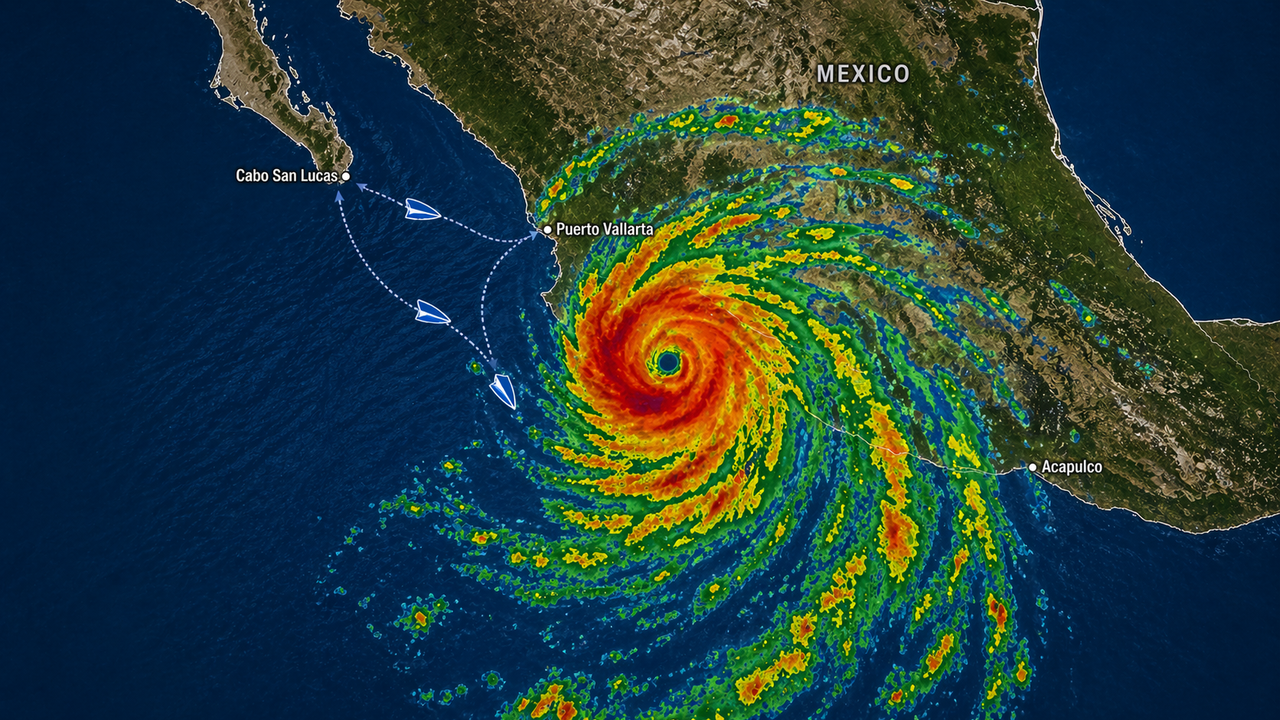
The Mexican Riviera isn't one destination - it's five or six distinct ports with very different hurricane histories and geographic exposure. A storm that closes Mazatlán may leave Puerto Vallarta untouched. A system churning 500 miles offshore can still kick up swells that cancel tender operations in Cabo. What the record shows:
- Puerto Vallarta sits inside Banderas Bay, one of the largest bays on Mexico's Pacific coast. The Sierra Madre mountains surrounding the bay have deflected or weakened most approaching storms - only a handful of significant direct hits in Puerto Vallarta's recorded history, most notably Hurricane Kenna in 2002 and Hurricane Patricia in 2015. When Patricia made landfall in 2015 as the strongest storm ever measured on Earth, Puerto Vallarta experienced rain and light wind and was back to normal cruise operations within days.
- Cabo San Lucas has less geographic protection and sits at the exposed southern tip of Baja California. Hurricane Odile made direct landfall there in September 2014 as a Category 4 with 125 mph winds - the strongest Baja strike in the satellite era. 30,000 tourists were stranded and 92% of Baja California Sur lost power. Cabo was largely operational again within seven weeks.
- Mazatlán is more exposed than Puerto Vallarta and has absorbed several direct strikes over the decades, including a Category 3 landfall in 1975 that destroyed 7,000 homes, and significant impacts from Tico (1983) and Kenna (2002). Its position on open coastline without the bay protection that shields Puerto Vallarta means a well-aimed storm creates real disruption.
- The bigger passenger-facing risk isn't a direct hit - it's what happens when a storm is 400 or 600 miles away. Swells from a distant system can make tender ports like Cabo impassable. High winds trigger port closures. Cruise lines reroute 48-72 hours in advance, often swapping in Ensenada or adding sea days. Itinerary disruptions in September and October are periodic and normal - not rare emergencies.
- Travel insurance matters more on hurricane-season sailings than any other time of year. Standard policies cover prepaid non-refundable expenses when a port is skipped due to a covered weather event. Cancel-for-any-reason coverage is a different product - ask before you book, not after. Heather at Flow Voyages can walk you through which coverage makes sense for a specific sailing.
Article Index
The Eastern Pacific runs from Mexico and Central America west to 140°W longitude. By storm count, it's only behind the Western Pacific typhoon belt in activity - an average season (based on NOAA's 30-year climatological period from 1991 to 2020) produces 15 named storms, 8 hurricanes, and 4 major hurricanes. The season officially runs May 15 to November 30, with peak activity in late August. Unlike the Atlantic, which spikes hard around September 10, the Eastern Pacific spreads its activity more evenly from late June through early October.
Don't worry, it is highly unlikely for hurricanes to pose any sort of danger to cruise ships!
Most of those storms never threaten Mexican cruise ports. The dominant track is west-northwest, carrying systems out to open ocean. A smaller number turn north along the Baja coast, and fewer still make landfall on the mainland. What changes that calculus is rapid intensification - the pattern where a storm goes from marginal to catastrophic in less than 24 hours over warm, deep water.
The Rapid Intensification Problem
Three of the most significant Pacific Mexico storms in the modern record share one trait: they intensified far faster than forecast models predicted.
Hurricane Kenna in October 2002 went from 40 mph to 140 mph in 42 hours before making landfall near San Blas, Nayarit, as a Category 4. Hurricane Patricia in October 2015 intensified 125 mph in 24 hours to reach 200 mph sustained winds - the strongest storm ever recorded anywhere on Earth - before weakening rapidly over the Sierra Madre after a compact landfall near Cuixmala, Jalisco, sparing Puerto Vallarta and Manzanillo most of its force. Hurricane Otis in October 2023 intensified 110 mph in 24 hours to reach 165 mph at landfall near Acapulco, becoming the strongest Eastern Pacific hurricane ever to make landfall - and NHC later cited Otis as their largest 48-hour intensity forecast error in the basin in recent history.
This pattern matters for cruise passengers because cruise lines need lead time to reroute. Most itinerary decisions happen 48-72 hours before a ship reaches the affected port. When a storm intensifies in 24 hours or less, those windows compress. The practical result isn't that ships end up in danger - cruise lines err heavily toward caution - but that itinerary changes arrive with less notice than passengers expect.
Port by Port: Hurricane Risk Across Pacific Mexico
The Mexican Riviera isn't one destination with one risk profile. Each port sits in a different geography, faces different storm tracks, and has a different history. Here's what the record shows for each.
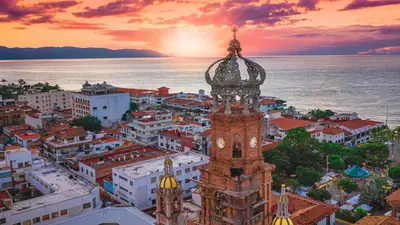
Puerto Vallarta and the Bay of Banderas
Puerto Vallarta sits at the eastern end of Banderas Bay, which stretches 42 kilometers from Punta de Mita in the north to Cabo Corrientes in the south - one of the largest bays on Mexico's Pacific coast. The Sierra Madre Occidental mountains rise directly from the coastline surrounding the bay. That geography does real work: storms approaching from the southwest tend to deflect around Cabo Corrientes, and systems that make landfall in the region typically weaken rapidly once they hit the mountain terrain.
The result is a port with one of the more favorable natural positions on the Pacific Mexico coast. Significant direct hurricane impacts since modern records began include Hurricane Kenna in 2002 - which made landfall near San Blas, 60 miles north, producing storm surge that damaged the Malecón and flooded waterfront hotels, with no deaths in the city - and Hurricane Patricia in 2015, which made landfall roughly 100 miles south and produced minimal damage in Puerto Vallarta itself.
That history doesn't make Puerto Vallarta immune. Heavy rainfall from distant storms routinely causes flooding in the river valleys surrounding the city. High surf and swell effects close beaches and disrupt water activities. A storm that tracks slightly east of the historical pattern would change the exposure entirely. But the port's record of resilience is real, and cruise lines treat it as one of the more reliable Mexican Riviera calls even during active periods.
Cabo San Lucas and the Baja Exposure
Cabo San Lucas sits at the southern tip of Baja California Sur, where the Pacific and the Sea of Cortez meet. There's no bay to deflect approaching storms. Baja is directly in the path of systems that develop off the southwestern Mexican coast and track northwest - the second most common Eastern Pacific track.
Hurricane Odile in September 2014 demonstrated what a direct hit looks like. The storm made landfall near Cabo as a Category 4 with sustained winds of 125 mph. Power went out across 92% of Baja California Sur, the Los Cabos airport closed, and approximately 30,000 tourists sheltered in place. Within nine days, power was restored to 95% of customers. Within seven weeks, roughly 3,000 hotel rooms and 70% of restaurants were open. By early 2015, most of Los Cabos had recovered. The tourism infrastructure rebuilt faster than most observers expected, in part because the local economy depended on it.
Cabo also has a structural consideration for cruise passengers: it's a tender port. Ships anchor offshore, and guests take small boats to the pier. Elevated swells - from a storm that's nowhere near Cabo - are enough to suspend tender operations for the day. Passengers should treat any Cabo visit in September or October as a weather-dependent proposition, even when conditions elsewhere look clear.
Mazatlán, Manzanillo, and the Sinaloa Coast
Mazatlán sits on an open peninsula in Sinaloa without significant geographic protection. The city has absorbed several significant storms over its history, including a surprise Category 4 strike in 1943 that hit with almost no warning, a Category 3 landfall from Hurricane Olivia in 1975 that destroyed 7,000 homes, and Hurricane Tico in 1983 which made landfall nearby at Category 4 intensity and caused $200 million in damage. More recently, Hurricane Orlene approached as a Category 4 in October 2022 before weakening to Category 1 at landfall 45 miles southeast of the city.
Manzanillo, further south in Colima state, appears on longer Mexican Riviera itineraries and Panama Canal routings. It's also a major commercial shipping port. Historically it has been exposed to significant storms - including the unnamed 1959 Category 5 storm that struck nearby and killed an estimated 1,800 people. For cruisers, Manzanillo represents a port that comes up less frequently but deserves the same weather-season awareness as the more common stops.
Acapulco and the South Pacific Mexico Coast
Acapulco has been a Mexico cruise port since the 1950s - a classic stop for Panama Canal cruises and longer trans Pacific voyages.
In October 2023, Otis made landfall five miles south of Acapulco as a Category 5 hurricane with 165 mph sustained winds - the strongest Eastern Pacific hurricane landfall ever recorded. The storm had been a modest tropical system less than 24 hours before. Forecasters issued a Category 5 warning fewer than six hours before landfall. The resulting damage was catastrophic: an estimated $12-16 billion in losses, roughly 80% of the city's hotels damaged, and 52 confirmed deaths. It remains the costliest tropical cyclone in Mexico's history.
Acapulco's recovery has been underway since. By late 2025, a major international cruise ship docked there following a weather-related diversion - the port's first such call in roughly 15 years, per specialist cruise publications. Global Ports Holding has taken a 24-year operating concession for the Acapulco cruise terminal, and Carnival Cruise Line has signaled a planned return to Acapulco in 2027 - with Carnival Legend scheduled to call there as part of a repositioning itinerary. The port isn't fully back yet, but it's on a defined recovery path.
Otis also reset assumptions about the southern Pacific Mexico coast more broadly. Before Otis, only two storms in modern records had made direct landfall within 50 miles of Acapulco, and both were Category 1. The rapid intensification that produced Otis - fueled by anomalously warm sea surface temperatures - is the same phenomenon climate scientists expect to see more frequently as ocean temperatures rise.
What Disruption Actually Looks Like on a Mexican Riviera Cruise
Hurricane Patricia provides a useful illustration of a typical weather event on this coast. When Patricia approached in October 2015, cruise lines adjusted course days out. Patricia made landfall in a sparsely populated stretch between Puerto Vallarta and Manzanillo. Within 48 hours, ships were returning to normal. Scheduled Puerto Vallarta calls resumed within days of landfall.
That's the pattern. Here's how it typically plays out for passengers:
- Itinerary change notification, 48-72 hours out. Cruise lines make rerouting decisions well before conditions deteriorate. You'll get an email or onboard announcement - a port is being skipped, a different port substituted, or a sea day added. Ensenada is the most common substitute for missed Mexican Riviera ports on West Coast sailings.
- Shore excursion refunds, automatic. Anything booked through the cruise line gets refunded to your onboard account when a port is canceled. Excursions booked independently don't come with that guarantee - another reason to book through the ship in October.
- Higher seas on sea days. Even when no port is affected, a distant storm running parallel to your course can produce notable swell. Not dangerous, but enough to close the pool deck, rock the ship overnight, and send first-time cruisers to the medical center for seasickness medication.
- Occasionally, a late change. When rapid intensification compresses the forecast window - as it did with Kenna, Patricia, and Otis - itinerary decisions arrive with less lead time than passengers expect. The cruise line is still acting on the best available data. It's just that the data window got shorter.
October historically produces the most itinerary disruptions on Mexican Riviera sailings, based on how cruise lines have responded over the past decade of weather events. September runs close. If you're booking a 7-night from Los Angeles to Puerto Vallarta, Mazatlán, and Cabo in either month, hold port calls loosely and treat a smooth passage as a genuine bonus.
Planning Cruises Around Pacific Hurricane Season
The practical question most people are actually asking is: should I book a September or October Mexican Riviera cruise at all? The honest answer is yes, with eyes open.
These sailings typically come with lower fares than peak winter season. The ports are less crowded. The Sierra Madre mountains are at their greenest from the summer rains. Puerto Vallarta's rainy-season afternoon storms are genuinely dramatic and beautiful if you're not trying to run a shore excursion through them. A lot of people love this time of year in Pacific Mexico.
What to do before you book: get travel insurance that specifically covers cruise itinerary interruptions due to weather, confirm what your policy covers for missed ports versus canceled voyages, and book shore excursions through the cruise line for the guaranteed refund if a port is skipped. Heather at Flow Voyages has navigated weather-season sailings across this coast for years and can advise on which itineraries and departures carry more or less exposure in a given season.
Pacific Mexico Hurricanes Are Not Uncommon But Don't Worry, The Risk Is Manageable
The Eastern Pacific doesn't get the same attention as the Atlantic hurricane season - no Weather Channel wall-to-wall coverage, no annual name countdown starting in June. Most people booking a Mexican Riviera cruise in September have never thought about it.
The season is real. Storms form in this basin at roughly the same rate as the Atlantic, with peaks that overlap directly with West Coast cruise deployment windows. What's different from the Caribbean is the geography: most storms track west, most ports have some protective terrain, and the infrastructure for handling disruptions - at the cruise line level and in the ports themselves - has gotten meaningfully better after storms like Odile and Otis exposed gaps.
Book the September sailing. Know that October is the most active month. Opt-in on cruise insurance, hurricanes are just one of many factors that you want to prepare for when booking a cruise.

Thanks for reading. We hope this was helpful!
Why stop now?
Participate In Our Polls | Ask or Answer A Cruise Question | Contact Heather to Book Your Next Cruise!